
|
|
|
National Weather Service issues Winter Storm Warning, Wind Advisory National Weather Service-Missoula has issued a Winter Storm Warning for the Northern and Southern Clearwater Mountains and a Wind Advisory for the Orofino/Grangeville Region from Sunday afternoon through Monday afternoon. 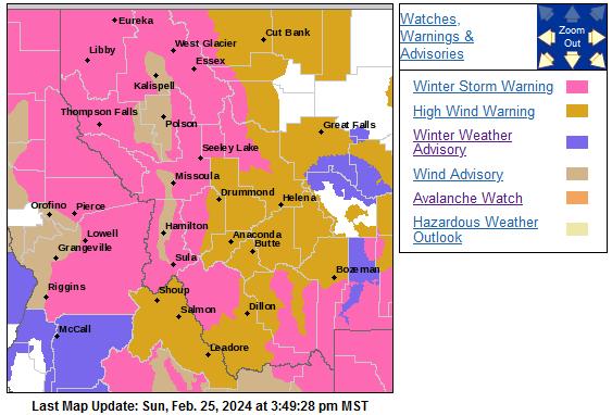 Clearwater Mountains Heavy snow is expected with total snow accumulations 2 to 6 inches in the valleys and 10 to 20 inches in the mountains including Lolo and Lost Trail passes. Winds gusting as high as 40 miles per hour in the valleys and up to 60 mph in the mountains. Areas of particular note are: Pierce, Elk River, Idaho Highway 11 Pierce to Headquarters, U.S. Highway 12 Lowell to Lolo Pass, Lolo Pass, Elk City, Dixie, and Highway 93 Sula to Lost Trail. The warning is from 4 p.m. Pacific Standard Time Sunday to 1 p.m. PST Monday. Travel could be very difficult to impossible. The hazardous conditions could impact the Monday morning and evening commutes. Strong winds could cause extensive damage to trees and power lines. The strongest winds and heaviest snowfall will be during overnight into the morning hours. Pierce, elevation 3,085 feet Sunday night: Rain before 1 a.m., then rain and snow. Snow level 5,100 feet lowering to 3,600 feet after midnight. Low around 27. Breezy, with a west-southwest wind around 23 mph, with gusts as high as 34 mph. Chance of precipitation is 100%. New snow accumulation of 1 to 2 inches possible. Monday: Snow. High near 33. West wind 13 to 18 mph, with gusts as high as 26 mph. Chance of precipitation is 100%. New snow accumulation of 2 to 4 inches possible. Monday night: Snow. Low around 20. West southwest wind 7 to 9 mph. Chance of precipitation is 90%. New snow accumulation of 2 to 4 inches possible. Orofino/Grangeville Region, Lower Hells Canyon/Salmon River Region A Wind Advisory is in effect from 1 p.m. Sunday to 10 a.m. PST Monday. Southwest winds 20 to 30 mph with gusts up to 60 mph are expected with total snow accumulations of a trace to 3 inches in the valleys and 2 to 6 inches in the higher elevations including Whitebird summit. Areas of particular note are: Orofino/Grangeville Region and Lower Hells Canyon/Salmon River Region. Gusty winds will blow around unsecured objects. Tree limbs could be blown down and a few power outages may result. The strongest winds and heaviest snowfall will be during the overnight hours into the morning. Winds this strong can make driving difficult, especially for high profile vehicles. Use extra caution. Orofino, elevation 1,039 feet Sunday night: Rain. Snow level 5,500 feet lowering to 2,200 feet after midnight . Low around 35. Breezy, with a west wind 21 to 29 mph, with gusts as high as 44 mph. Chance of precipitation is 100%. New precipitation amounts between a quarter and half of an inch possible. Monday: Snow. High near 42. Breezy, with a west wind 14 to 23 mph, with gusts as high as 33 mph. Chance of precipitation is 80%. New snow accumulation of less than a half inch possible. Monday night: Snow. Low around 28. West southwest wind 6 to 10 mph. Chance of precipitation is 80%. New snow accumulation of less than one inch possible.  |
| Window on the Clearwater P.O. Box 2444 Orofino, ID 83544 Phone: (208) 476-0733 Fax: (208) 476-4140 |