
|
|
Large crowd gathers Saturday to learn about Bedrock Fire A large crowd gathered at LeBaron Park at Cavendish Saturday to learn about the Bedrock Fire which was report about 1 p.m. Wednesday and has grown to 9,005 acres with no containment. 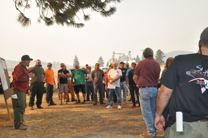 Josh Harvey, Idaho Department of Lands Fire Bureau Type 3 Team Incident Commander, addresses the crowd gathered Saturday to learn about the Bedrock Fire. The Bedrock File is located near Lenore, Idaho, on the north side of U.S. Highway 12 and the Clearwater River between Lewiston and Orofino (approximately 26 miles east of Lewiston and 16 miles west of Orofino) in Nez Perce County (46.531 latitude, -116.6 longitude). The Idaho Department of lands established an incident command post in Orofino.  The fire is being attacked on three fronts by Division Alpha on the west side of the perimeter, Division Whiskey across the northeast corner, and Division Golf covering the remainder of the southern boundary just north of the Clearwater River. Resources are deployed across all three divisions, with efforts focused on exploiting opportunities to cut off the fire near the Bedrock Creek drainage which is close to Cavendish, and to secure the Louse Creek drainage, which is a tributary of Bedrock Creek. For all divisions, protecting property from loss remains a high priority. As of Friday, 2 primary residences, 1 other residence and 12 outbuildings had been lost. Personnel will continue inventorying residences and other structures lost or damaged in the fire. At least 4 structural engines and crew members staffed the night shift Friday evening to protect residences. Additionally, all 12 wildland engines and crews from Friday's day shift spent the night on the fire, working until at least midnight to protect structures. Clearwater County Sheriff Chris Goetz posted on his Facebook page Saturday evening: "They are currently doing a burnout operation at the head of Bedrock Creek near Mciver Rd. There is a lot of fire in the area please avoid the area so that firefighters can work. "As of 7:20 pm the burnout operation is ongoing but has been successful so far. There are several additional resources arriving including engines, that will be the night shift tonight. The are using the Cream Ridge Church as their staging area so watch out for heavy fire traffic in that area." Evacuations and closures Saturday at 8 a.m. Nez Perce County Emergency Management reported:
Clearwater County Road Closures
Fire Restrictions Due to the high threat of wildfire danger in northern Idaho, local land management agencies implemented Stage II Fire Restrictions on all lands within the Grangeville Fire Restriction Area. Please visit https://www.idl.idaho.gov/fire-management/fire-restrictions-finder/ for current restriction information. Temporary Flight Restrictions (TFR) There is a TFR in place for air space over the Bedrock Fire. For detailed information about the TFR visit https://tfr.faa.gov/save_pages/detail_1_5867.html. Remember, temporary flight restrictions also apply to unmanned aircraft systems (UAS) or drones. "If you fly, we can't!" Flying a drone in restricted air space is illegal. Help spread this important message on social media by sharing this post on Facebook. Primary and cooperating agencies The Idaho Department of Lands is the primary agency on this incident and extends thanks for the tremendous support provided by the Nez Perce County Sheriff's Office, Clearwater County Sheriff's Office, Orofino Fire Department, Wheatland Fire Protection District, Lewiston Fire Department, Moscow Volunteer Fire Department, Deary Volunteer Fire Department, Troy Volunteer Fire & Rescue, Kendrick Volunteer Fire Department, Sunnyside Ridge Rural Fire District, and Big Canyon Fire District. Where to find information
|
|
| Window on the Clearwater P.O. Box 2444 Orofino, ID 83544 Phone: (208) 476-0733 Fax: (208) 476-4140 |